The Beholder Critical Minerals platform is a professional GIS system designed specifically for geological data analysis and critical minerals exploration. This specialized geoportal combines high-resolution mapping capabilities with comprehensive geological datasets to support mining and exploration industries.
    <div class="key-features">
        <div class="feature">
            <div class="feature-icon">🗺️</div>
            <h3>Advanced GIS</h3>
            <p>Professional-grade geological information system</p>
        </div>
        <div class="feature">
            <div class="feature-icon">💎</div>
            <h3>Critical Minerals</h3>
            <p>Specialized tools for mineral exploration</p>
        </div>
        <div class="feature">
            <div class="feature-icon">📊</div>
            <h3>Data Analysis</h3>
            <p>Comprehensive geological datasets</p>
        </div>
        <div class="feature">
            <div class="feature-icon">🚀</div>
            <h3>High Performance</h3>
            <p>Optimized for large-scale operations</p>
        </div>
    </div>
</div>
🏗️ Interface Structure
The platform interface is thoughtfully organized into three main components, each designed to provide intuitive access to specific functionalities:
1
Top Navigation Bar
Quick access to main functions, user account, and system settings
Learn More →<a href="/wiki/interactive-maps" class="component-card">
<div class="component-number">2</div>
<div class="component-content">
<h3>Left Sidebar</h3>
<p>Layer management, search tools, and data filters</p>
<span class="component-link">Learn More →</span>
</div>
</a>
<a href="/wiki/interactive-maps" class="component-card">
<div class="component-number">3</div>
<div class="component-content">
<h3>Main Map Area</h3>
<p>Interactive geological map with visualization tools</p>
<span class="component-link">Learn More →</span>
</div>
</a>🖥️ Platform Interface Overview
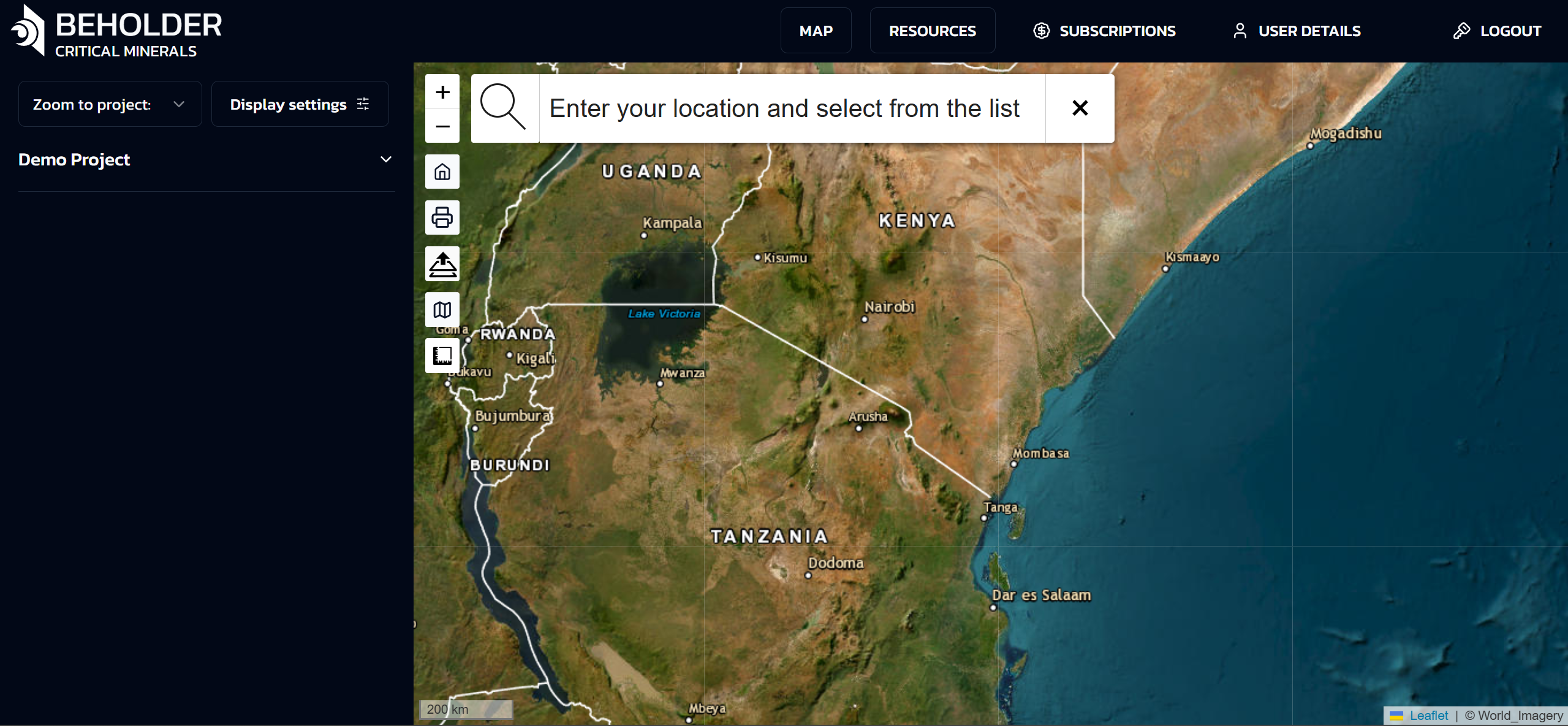
1
Navigation Bar
2
Sidebar
3
Map Area
Getting Started as a Geologist
Professional Account Setup
- Account Registration: Sign up with your professional credentials
- Verification: Submit geological qualifications for verification
- Profile Configuration: Set up your specialization areas and interests
- Team Access: Invite team members and collaborators
Initial Platform Tour
- Interactive Tutorial: 15-minute guided tour of geological features
- Sample Projects: Access to example exploration projects
- Data Import: Learn how to upload your existing geological data
- Tool Overview: Introduction to geological analysis tools
Geological Analysis Tools
Map Visualization
The portal provides multiple visualization modes:
Geological Map Overlay
- Stratigraphic Units: Display geological formations and rock units
- Structural Features: Show faults, folds, and other structural elements
- Mineral Occurrences: Plot known mineral deposits and occurrences
- Custom Layers: Upload and display your own geological maps
Satellite Imagery Analysis
- Multispectral Bands: Analyze different spectral bands for geological features
- False Color Composites: Create custom band combinations for mineral detection
- Temporal Analysis: Compare imagery across different time periods
- Resolution Options: Switch between different spatial resolutions
Mineral Prediction Tools
AI Mineral Predictions
- Confidence Mapping: Visualize prediction confidence across your area of interest
- Mineral Type Selection: Focus on specific minerals relevant to your project
- Probability Thresholds: Adjust sensitivity for different exploration phases
- Uncertainty Analysis: Understand model limitations and uncertainties
Geological Context Integration
- Formation Analysis: Correlate predictions with geological formations
- Structural Controls: Analyze how structural features influence mineralization
- Alteration Mapping: Identify hydrothermal alteration zones
- Weathering Effects: Account for surface weathering in predictions
Data Analysis and Interpretation
Statistical Analysis
- Spatial Statistics: Calculate spatial correlation and clustering
- Probability Analysis: Statistical assessment of mineral potential
- Trend Analysis: Identify regional trends and patterns
- Anomaly Detection: Find statistically significant anomalies
Cross-Validation Tools
- Field Data Integration: Compare predictions with field observations
- Drill Hole Analysis: Validate predictions against drilling results
- Sample Analysis: Integrate geochemical and petrographic data
- Historical Data: Compare with known mineral occurrences
Workflow Integration
Project Management
- Project Creation: Set up new exploration projects
- Area Definition: Define your area of interest and boundaries
- Data Organization: Organize geological data by project
- Team Collaboration: Share projects with team members
- Version Control: Track changes and maintain project history
Data Import and Export
- Supported Formats: Shapefile, KML, GeoTIFF, NetCDF, CSV
- Coordinate Systems: Support for all major coordinate systems
- Data Validation: Automatic validation of geological data
- Metadata Preservation: Maintain geological metadata and attributes
Report Generation
- Automated Reports: Generate standard geological reports
- Custom Templates: Create custom report templates
- Map Production: High-quality map production for publications
- Data Tables: Export geological data in various formats
Advanced Geological Features
Stratigraphic Analysis
- Formation Mapping: Map and analyze geological formations
- Correlation: Correlate formations across different areas
- Thickness Analysis: Calculate and visualize formation thicknesses
- Depositional Environment: Analyze depositional environments
Structural Geology
- Fault Analysis: Map and analyze fault systems
- Fold Analysis: Identify and analyze fold structures
- Lineament Analysis: Detect and analyze linear features
- Stress Analysis: Analyze stress fields and deformation
Geochemical Integration
- Sample Data: Import and analyze geochemical samples
- Contour Mapping: Create geochemical contour maps
- Anomaly Detection: Identify geochemical anomalies
- Statistical Analysis: Perform statistical analysis on geochemical data
Petrographic Analysis
- Thin Section Data: Integrate petrographic observations
- Mineral Identification: AI-assisted mineral identification
- Texture Analysis: Analyze rock textures and fabrics
- Alteration Mapping: Map alteration assemblages
Best Practices for Geologists
Data Quality
- Data Validation: Always validate imported geological data
- Metadata Documentation: Maintain comprehensive metadata
- Quality Control: Implement quality control procedures
- Version Management: Keep track of data versions and updates
Interpretation Guidelines
- Multi-Scale Analysis: Analyze at multiple scales
- Cross-Validation: Validate AI predictions with geological knowledge
- Uncertainty Assessment: Always consider prediction uncertainties
- Field Verification: Plan field verification of predictions
Collaboration
- Team Communication: Use built-in communication tools
- Data Sharing: Share relevant data with team members
- Review Process: Implement peer review processes
- Documentation: Maintain comprehensive project documentation
Case Studies
Lithium Exploration in Nevada
- Project Overview: 500km² lithium exploration project
- AI Predictions: 94% accuracy in identifying lithium-bearing clays
- Field Validation: 87% of high-confidence predictions confirmed
- Economic Impact: 40% reduction in exploration costs
Graphite Exploration in Canada
- Project Overview: 200km² graphite exploration project
- Geological Context: Integration with Precambrian geology
- AI Results: 91% accuracy in graphite detection
- Drilling Results: 78% success rate in drilling AI-identified targets
Rare Earth Elements in Australia
- Project Overview: 1000km² REE exploration project
- Complex Geology: Integration with igneous and metamorphic rocks
- AI Performance: 89% accuracy across multiple REE types
- Resource Estimation: Improved resource estimation accuracy
Training and Support
Educational Resources
- Video Tutorials: Step-by-step video guides
- Webinars: Regular webinars on geological applications
- Documentation: Comprehensive technical documentation
- Best Practices: Industry best practices and guidelines
Technical Support
- Geological Support: Dedicated geological support team
- Technical Issues: 24/7 technical support
- Feature Requests: Submit requests for new features
- User Community: Connect with other geologists using the platform
Professional Development
- Certification Programs: Professional certification in AI-assisted exploration
- Workshops: Hands-on workshops and training sessions
- Conferences: Annual user conferences and meetings
- Research Collaboration: Opportunities for research collaboration
Integration with External Software
GIS Software
- ArcGIS Integration: Direct integration with ArcGIS
- QGIS Support: Export data for QGIS analysis
- MapInfo Compatibility: Support for MapInfo formats
- Custom GIS: API access for custom GIS applications
Geological Software
- Leapfrog Integration: Export data for 3D modeling
- Surpac Support: Integration with Surpac geological software
- Datamine Compatibility: Support for Datamine formats
- Custom Tools: API access for custom geological tools
Future Developments
Upcoming Features
- 3D Geological Modeling: Three-dimensional geological visualization
- Machine Learning Training: Tools for training custom models
- Advanced Analytics: Enhanced statistical and analytical tools
- Mobile Field Tools: Mobile applications for field data collection
Research Opportunities
- Collaborative Research: Opportunities for research collaboration
- Data Sharing: Access to anonymized exploration data
- Model Development: Participate in model development
- Publication Support: Support for academic publications
For additional support or questions specific to geological applications, please contact our geological support team at geology@beholder.earth.